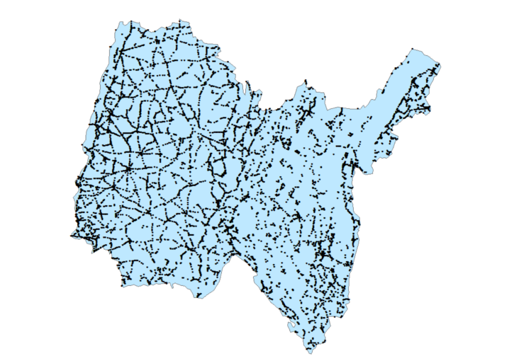
Carrefours des routes départementales - Département de l'Ain
Point d'intersection d'une Route Départementale avec une autre voie ouverte à la circulation quelle soit départementale ou non. Le champ CARREF_ZON permet de connaitre le type d'intersection (4=giratoire). Les intersections de type non giratoire ne sont pas forcément exhaustives. - Mise à jour Février 2017
Les dernières mise à jour de ces données sont disponibles depuis le site opendata du Conseil Départemental de l'Ain (CD 01) : http://departement-ain.opendata.arcgis.com
Simple
- Date (Revision)
- 2017-02-27T11:08:07
- Date (Publication)
- 2017-02-27
- Date (Revision)
- 2017-02-27
- Date (Creation)
- 2017-02-27
- Citation identifier
- https://catalogue.open-datara.fr/geonetwork/srv/2738f971-ec71-40b8-9685-b8d7af3e68f1
- Point of contact
-
Organisation name Individual name Electronic mail address Role Conseil Départemental de l'Ain (CD 01)
Owner
- Place
-
-
RHONE ALPES
-
-
Departement Rhone-Alpes
-
-
AIN
-
-
OPENDATA
-
-
open data
-
données ouvertes
-
- Keyword
-
CD Ain
- Keyword
-
Grand public
- Keyword
-
Routier
- Keyword
-
Spécification départementale
- Type
- Theme
- Date (Publication)
- 2024-10-08
- Access constraints
- Restricted
- Use constraints
- Copyright
- Other constraints
-
Pas de restriction d’accès public selon INSPIRE
- Spatial representation type
- Vector
- Denominator
- 5000
- Language
-
fre
- Character set
- UTF8
- Topic category
-
- infrastructures de transport
- Description
-
Ain
))
- Reference system identifier
- EPSG / RGF93 / Lambert-93 (EPSG:2154) / 7.4
- OnLine resource
-
Protocol Linkage Name WWW:LINK-1.0-http--link
http://departement-ain.opendata.arcgis.com Site Opendata du Conseil Départemental de l'Ain (CD 01)
OGC:WMS-1.1.1-http-get-map
https://carto.open-datara.fr/cgi-bin/mapserv? l_carrefour_route_p_001
OGC:WFS-1.0.0-http-get-capabilities
https://carto.open-datara.fr/cgi-bin/mapservwfs? l_carrefour_route_p_001
WWW:LINK-1.0-http--link
https://catalogue.open-datara.fr/rss/atomfeed/atomdataset/2738f971-ec71-40b8-9685-b8d7af3e68f1 Accès au lien ATOM de téléchargement
WWW:DOWNLOAD-1.0-http--download
https://telechargement.open-datara.fr/download/2738f971-ec71-40b8-9685-b8d7af3e68f1 Accès au téléchargement des données
WWW:LINK-1.0-http--link
https://catalogue.open-datara.fr/geosource/consultationWMS?IDT=18925894 Accès à la visualisation des données
- Hierarchy level
- Dataset
- Statement
-
Ces données sont issues de la base de données routières gérée par le Département de l'Ain.
Metadata
- File identifier
- 2738f971-ec71-40b8-9685-b8d7af3e68f1 XML
- Metadata language
-
fre
- Character set
- UTF8
- Hierarchy level
- Dataset
- Date stamp
- 2019-03-04T12:35:47
- Metadata standard name
-
ISO 19115:2003/19139
- Metadata standard version
-
1.0
- Metadata author
-
Organisation name Individual name Electronic mail address Role Conseil Départemental de l'Ain (CD 01)
Author
Overviews
Spatial extent
Provided by
