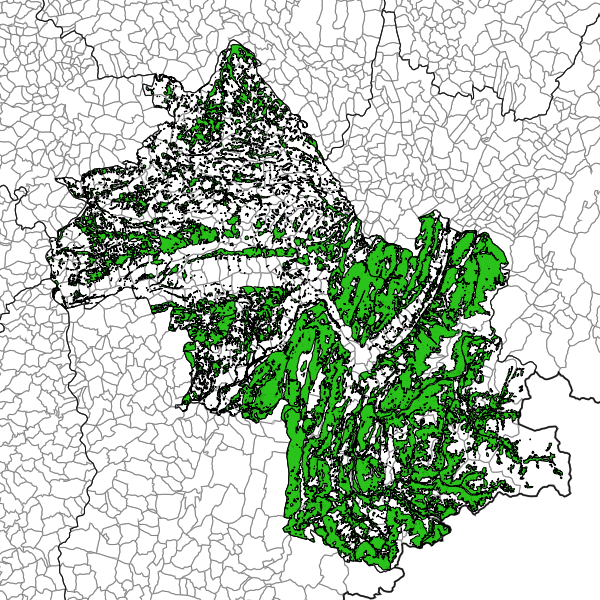
Forêts et landes de plus de 4 hectares - Isère
Cartographie des forêts et landes de plus de 4ha (à l’exception des formations herbacées).
Simple
- Date (Revision)
- 2025-04-16T11:51:36
- Date (Creation)
- 2024-04-09
- Citation identifier
- https://catalogue.open-datara.fr/geonetwork/srv/1009ad63-bbf3-4bcd-8c05-079903e839e5
- Point of contact
-
Organisation name Individual name Electronic mail address Role DDT 38 (Direction Départementale des Territoires de l'Isère)
Bureau SIG central et OBServatoire
Owner
- Place
-
-
RHONE ALPES
-
-
Departement Auvergne-Rhone-Alpes
-
-
ISERE
-
-
GEMET - INSPIRE themes, version 1.0
-
-
Zones à risque naturel
-
Occupation des terres
-
-
Domaines
-
-
Grand public
-
DDT Isère
-
Spécification locale
-
DFCI
-
- Use limitation
-
Licence Ouverte / Open Licence Version 2.0 https://www.etalab.gouv.fr/wp-content/uploads/2017/04/ETALAB-Licence-Ouverte-v2.0.pdf
- Access constraints
- Intellectual property rights
- Use constraints
- Copyright
- Spatial representation type
- Vector
- Denominator
- 25000
- Language
-
fre
- Character set
- UTF8
))
- Supplemental Information
-
Département de l'Isère
- Reference system identifier
- EPSG / RGF93 / Lambert-93 (EPSG:2154) / 7.4
- Distribution format
-
Name Version ZIP
- OnLine resource
- Hierarchy level
- Dataset
- Statement
-
Filtre sur BD Forêt v2 : élimination des formations herbacées. Puis fusion des massifs forestiers contigus avant de filtrer les massifs supérieurs à 4 Ha.
l_mass_forest_4ha_s_038
Metadata
- File identifier
- 1009ad63-bbf3-4bcd-8c05-079903e839e5 XML
- Metadata language
-
fre
- Character set
- UTF8
- Hierarchy level
- Dataset
- Date stamp
- 2025-04-16T10:28:09.777393Z
- Metadata standard name
-
ISO 19115:2003/19139
- Metadata standard version
-
1.0
- Metadata author
-
Organisation name Individual name Electronic mail address Role DDT 38 (Direction Départementale des Territoires de l'Isère)
Bureau SIG central et OBServatoire
Owner
Overviews
Spatial extent
Provided by
